

Iguana Island Wildlife Refuge
Pedasí, Gulf of Panama, Eastern Tropical Pacific Ocean
Station 1:
The Fossils
Geological history of Isla Iguana
Location
Stand in front of the Ranger House and look out to sea.
Walk towards the light brown rocks at the end of El Cirial beach.
It can only be reached at low to mid tide. You may need to visit this station when the tide goes out.
Walk between the rocks to the one indicated in the photo. You will see impressions of snails, clams, starfish and other marine organisms. These rocks are the product of compression of fossils trapped between fine sediments, when the island began to emerge from the sea and was a area very calm waters.
On this site we will tell you the story of how Isla Iguana was formed.

_JPG.jpg)
In the center of the photo you can see the impression of a snail seen from above.

_JPG.jpg)
In the center of the photo you can see the impression of a snail seen from the side.
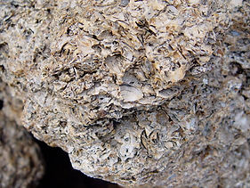
Impressions of clams, polychaete worms and other marine invertebrates.
_JPG.jpg)
Impressions of starfish and other marine invertebrates.
How was Iguana Island formed?
Years ago

20 million
About 20 million years ago, South America was separated from North America by a deep sea. Panama and Costa Rica were submerged and there was only one ocean, from which the Isthmus began to emerge, the product of large volcanic eruptions, which formed an archipelago.
Bibliography: Modified from Coates, A. 2001. In geological history, Panama has changed the world. In: Panama: Biological Bridge. Publisher Stanley S. Heckadon.

Part of Azuero began to form in Galapagos and tectonic plate movement began to move it towards archipelago in formation.
Isla Iguana emerged from lava eruptions from a submerged volcano.
8
millions

The island and its depths to the north and west are made up of magma that emerged of a volcano Subsea, it is known as intrusive basalt and forms columns by cooling rapidly when in contact with seawater.
The lines in the photograph show where the waves broke during the rise of the island from the seafloor.
20,000
years
back


During the last ice age, the sea dropped to about 130 m from its current level. The Gulf of Panama became a great valley covered with forests, Isla Iguana and Las Perlas were mountains above this valley.
The green line and deep brown masses show today's coastline. day and main íos to compare it with how it looked thousands of years ago.

10,300
years
behind


Some 10,300 years ago, Frailes del Sur and its lower area were islands. Isla Iguana was still a hill about 50 meters above the coastal plains of Pedasí.

9,250
years
behind


About 9,250 years ago the Northern Friars (Nuns) became islands.
Existing fishing bass began to form.
Isla Iguana was a high peninsula of the new coast line of Pedasí.


8,250
years
behind

About 8,250 years ago, Iguana once again became an island with a larger area than it is today, and the isolation of its land animals began due to a marine strait of about 3 km.


7,750
years
behind

About 7,750 years ago, the size of the island was reduced and the sea strait between the island and the mainland was increased.
Around this time coral began to grow around the island. The samples from the base of the El Cirial coral platform recorded an average age of 4,800 years and a maximum of 6,200 years.


Today

Today the isolation of the mainland is about 7 km from the beaches of Mariabé. The coral joined the basalt lobes and the island took on its current shape.
If the sea continues to rise due to climate change, the island will shrink. The coral is your natural protective barrier to this phenomenon. It will need to grow at the same rate as the rise to mitigate this impact.

Bibliography: Mathematical model elaborated by the author based on the graph of www.globalwarmingact.com.
For more information visit the following link:
Excerpt from the author's conference at the Azuero Ecological Project, Pedasí, on Dec. 15, 2012